
Cross-country ski trails Camp Dudemaine - Club de ski de fond d'Amos
Cross-country ski trails Camp Dudemaine - Club de ski de fond d'Amos
Amos, Amos Région
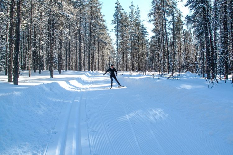
Come and enjoy 68 kilometers of groomed cross-country ski trails suitable for beginners and experts alike, whether you prefer classic skiing or skate skiing. Warm up in one of our on-trail shelters, then head back out for a few more kilometers!
Baby glider rentals are available for little ones.
- electrocardiogram Easy to Very demanding
- mountain 68 Km (Mixed)
- calendar seasonal
Points of service and interest
Category Name
 Parking
 Reception et services
Accessibility
Access Rights
![]() Access rights are required and subject to a fee.
Access rights are required and subject to a fee.
Pets are not allowed.
Directions to the Starting Point
From the airport road (Route 395), turn onto Chemin du Lac-des-Sources. After 500 meters, turn right onto Chemin du Lac-Dudemaine and follow it to the parking area near the main chalet.
Parking
Free
Coordinates
48°33'19.6"N | 78°13'42.9"W
Address
Route 395 South (towards the airport), Amos
![]() View Directions from Your Location on Google Maps
View Directions from Your Location on Google Maps
Contact Information
Phone: 1 819 732-8453
Email: skidefondamos@hotmail.com
Visit the Website
Visit the Facebook Page
Specifications
Trails
68 km of trails (22 km linear) maintained for both classic and skate skiing enthusiasts.
The network includes 9 trails: 3 easy, 4 difficult, and 2 very difficult, with one trail exclusively designed for classic skiing on a double track.
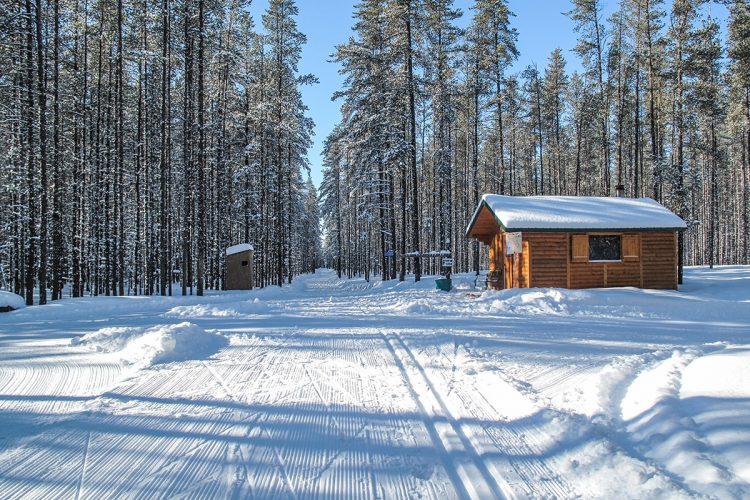
Shelters
4 heated shelters accessible on the trails
Services
- Welcome Chalet
- Equipment rentals
Natural Environment
Geography
During the last ice age, which began 100,000 years ago, a massive sheet of ice covered the entire province of Quebec. As these glaciers moved, they stripped away layers of rock and eroded the surface of the Canadian Shield. When the glaciers retreated, rivers flowed beneath the ice, carrying and depositing sediments in the form of elongated ridges, either straight or sinuous. The materials, subjected to immense water pressure, were rounded, smoothed, and sorted before being deposited. As the water currents slowed, sand, gravel, and rocks of varying shapes and sizes settled, forming what are known as eskers.
Eskers can range from a few meters to over a hundred kilometers in length. They are most common in regions where significant water flow occurred along the edges of ice caps during deglaciation. Though partially covered by clay deposits, which can make them appear smaller, eskers sometimes rise several meters above the surrounding plains.
The arrangement of materials within an esker acts like a sponge, absorbing and filtering rainwater and melting snow through its pores down to the bedrock. The clay covering the sides of the esker prevents the water from escaping.
The St-Mathieu–Lac Berry esker was formed during the retreat of the Hudson Ice Dome. Spanning over 70 kilometers (43.5 miles), it is arguably the most impressive esker in Abitibi-Témiscamingue. The water drawn from it is of exceptional natural purity, containing less than 200 PPM of dissolved minerals and a pH of 7.1, making it nearly perfectly balanced. Along this esker are the Eska spring, the St-Mathieu trout farm, and the potable water source for the town of Amos.
Comments social0
Tools ready to go
- map Guide map (PDF)
- Google driving directions
-
 Sunrise : 07:17
Sunset : 18:44 -
Equipment for rent Club de ski de fond d'Amos
Info & advice
- Animation et interprétation
- Care
- Carte et orientation
- Clothes
- Emergency
- Equipment
- Nutrition
- Prevention
- Prevention
Caution
This sheet has been prepared from information provided by outdoor enthusiasts deemed sufficiently reliable and experienced. Errors or omissions are always possible and Tourisme Abitibi-Témiscamingue cannot accept responsibility for any problem or accident that may arise from this sheet or be attributed to its use. If you notice any errors or omissions during your expedition, we would be very grateful if you would let us know by email pleinair@atrat.org in order to keep our information up to date.