
Aiguebelle national park Nordic Ski trails
Aiguebelle national park Nordic Ski trails
Rouyn-Noranda (Mont-Brun), Rouyn-Noranda
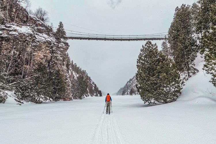
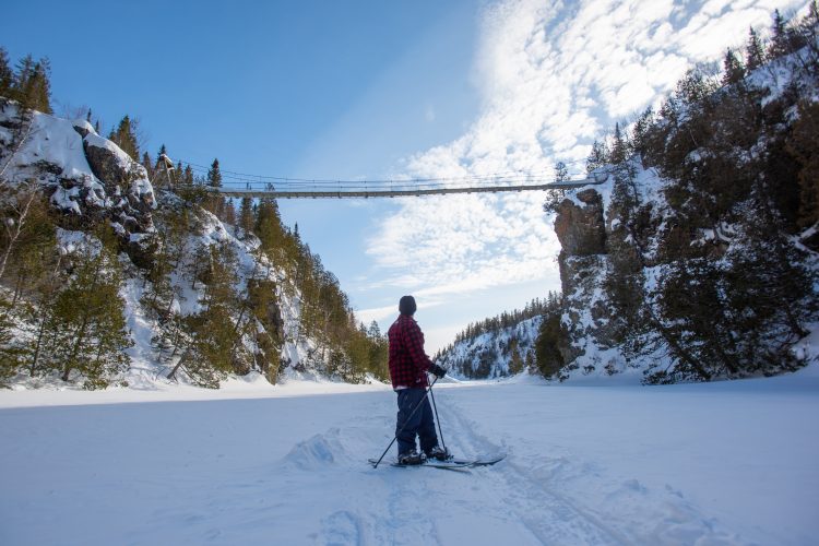
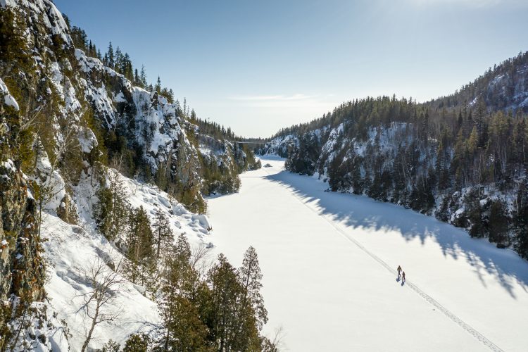
Do you dream of peace, fluidity, and gentle euphoria? Glide through the silent nature of Aiguebelle, draped in its heavy cloak of snow. Along its 30 km of marked trails, let it reveal its many charms: cliffs, frozen lakes, dense forests. Never have movements felt as pleasant and invigorating as these Nordic ski hikes, allowing you to set your own pace. And extend this peace into the night by staying in one of the 11 cozy shelters of the rustic camps.
- electrocardiogram Easy to Demanding
- mountain 32.3 Km (Mixed)
- calendar seasonal
Sections
Chemin d'accès déneigé
- electrocardiogram Easy
- mountain 2.43 km (Linear)
Sentier- Ski Nordique Les Failles Sect.Nord
- electrocardiogram Easy
- mountain 4.34 km (Linear)
Sentier-Ski Nordique L'Escapade Boréale Sect. Centre
- electrocardiogram Easy
- mountain 10.22 km (Linear)
Sentier-Ski Nordique L'Escapade Boréale Sect. Ouest
- electrocardiogram Easy
- mountain 12.83 km (Linear)
Sentier-Ski Nordique La Framboisière
- electrocardiogram Easy
- mountain 1.38 km (Linear)
Sentier-Ski Nordique Le Bourdon
- electrocardiogram Easy
- mountain 2.73 km (Linear)
Sentier-Ski Nordique Le Lièvre
- electrocardiogram Easy
- mountain 2.65 km (Linear)
Sentier-Ski Nordique Les failles Sect.Sud
- electrocardiogram Easy
- mountain 4.97 km (Linear)
Traverse-Failles sect.Nord-Sud
- electrocardiogram Easy
- mountain 0.47 km (Linear)
Snow-cleared access road
- electrocardiogram Easy
- mountain 2.43 km (Linear)
Nordic ski trail Les Failles North Sect.
- electrocardiogram Easy
- mountain 4.34 km (Linear)
Nordic ski trail L'Escapade Boréale Center sect.
- electrocardiogram Demanding
- mountain 10.22 km (Linear)
Nordic ski trail L'Escapade Boréale West sect.
- electrocardiogram Demanding
- mountain 12.83 km (Linear)
Nordic ski trail La Framboisière
- electrocardiogram Easy
- mountain 1.38 km (Linear)
Nordic ski trail Le Bourdon
- electrocardiogram Easy
- mountain 2.73 km (Linear)
Nordic ski trail Le Lièvre
- electrocardiogram Easy
- mountain 2.65 km (Linear)
Nordic ski trail Les Failles South sect.
- electrocardiogram Easy
- mountain 4.97 km (Linear)
Traverse-Failles North-South sect.
- electrocardiogram Easy
- mountain 0.47 km (Linear)
Points of service and interest
Category Name
-
 Reception et services
Centre de service Mont-Brun
48°25'50.0"N
Reception et services
Centre de service Mont-Brun
48°25'50.0"N
78°40'01.0"O -
 Parking
Stationnement du Camping du Sablon
48°26'55,193"N
Parking
Stationnement du Camping du Sablon
48°26'55,193"N
78°41'3,528"O -
 Tourist information
Centre de service Mont-Brun et Boutique Nature
(Parc national d'Aiguebelle)
48°26'55.191”N
Tourist information
Centre de service Mont-Brun et Boutique Nature
(Parc national d'Aiguebelle)
48°26'55.191”N
78°41'8.308”O -
Parking
Stationnement de la Route 1
48°28'4,194"N
78°39'13,494"O -
 Cottage for rent
La Demoiselle (lac Loïs)
48°35'51,569"N
Cottage for rent
La Demoiselle (lac Loïs)
48°35'51,569"N
78°40'58,142"O -
 Rustic camp for rent
La Cigale (en montagne)
48°27'21,488"N
Rustic camp for rent
La Cigale (en montagne)
48°27'21,488"N
78°42'50,228"O -
Rustic camp for rent
L'Amiral (lac de l'Esker)
48°30'26,344"N
78°40'18,024"O -
Rustic camp for rent
Le Patineur (lac Patrice)
48°30'47,95"N
78°44'3,723"O -
Rustic camp for rent
La Guêpe (lac La Haie)
48°29'06.2"N
78°41'51.3"O -
Rustic camp for rent
Le Dytique (Surplombe le lac Sault)
48°30'25,11"N
78°41'4,524"O -
Rustic camp for rent
Le Bourdon (lac du Sablon) fd
48°30'7,999"N
78°39'32,379"O -
Rustic camp for rent
L'Alucite (lac aux Bûcherons)
48°30'1,048"N
78°40'36,282"O -
 Point of interest
Pont arqué japonais
48°30'51.8"N
Point of interest
Pont arqué japonais
48°30'51.8"N
78°40'52.9"O -
Point of interest
Pont suspendu
48°27'49,249"N
78°42'7,513"O
Accessibility
Access Rights
![]() Required and payable|Visitors facilies
Required and payable|Visitors facilies
![]() Dogs allowed in certain areas of the park.
Dogs allowed in certain areas of the park.
Directions to reach the Aiguebelle National Park
MONT-BRUN SERVICE CENTER - SOUTH ENTRANCE (accessible year-round): Via the Mont-Brun district and Rang Hudon (southern entrance accessible year-round), about 50 km from downtown Rouyn-Noranda.
Address: 12373 Route d'Aiguebelle, Rouyn-Noranda, Québec, J0Z 2Y0
![]() View the route from your location on Google Map
View the route from your location on Google Map
From Val-d'Or:
Take Route 117 North for about 65 km, then turn right onto Mont-Brun Road (22 km on a paved road). At the Mont-Brun intersection, take Route d'Aiguebelle on your right. Drive through Mont-Brun village. At the bridge, turn right onto Route d'Aiguebelle. The park entrance is 8 km from Mont-Brun village. The Discovery and Service Center (reception) is on Route 2, 5 km from the entrance.
From Rouyn-Noranda:
Take Route 101 North. At D'Alembert, turn right onto Route d'Aiguebelle. Drive through Cléricy village and continue to Mont-Brun. At the Mont-Brun Road intersection, turn left. Drive through Mont-Brun village. At the bridge, turn right onto Route d'Aiguebelle. The park entrance is 8 km from Mont-Brun village. The Discovery and Service Center (reception) is on Route 2, 5 km from the entrance.
From La Sarre:
Take Route 101 South. At D'Alembert, turn left onto Route d'Aiguebelle. Drive through Cléricy village and continue to Mont-Brun. At the Mont-Brun Road intersection, turn left. Drive through Mont-Brun village. At the bridge, turn right onto Route d'Aiguebelle. The park entrance is 8 km from Mont-Brun village. Follow the signs to Route 2; the service center is 5 km from the entrance.
From Amos:
Take Route 109 South. At Rivière-Héva, turn right onto Route 117 North for about 28 km, then turn right onto Mont-Brun Road. At the Mont-Brun village intersection, take Route d'Aiguebelle on your right. Drive through Mont-Brun village. At the bridge, turn right onto Route d'Aiguebelle. The park entrance is 8 km from Mont-Brun village. Follow the signs to Route 2; the service center is 5 km from the entrance.
Contact
T 819 637-7322 Email: parc.aiguebelle@sepaq.com Visit Website Visit Facebook page
Framed access for dogs
![]() Dogs are allowed in Aiguebelle National Park, in certain designated areas.
Dogs are allowed in Aiguebelle National Park, in certain designated areas.
Main Framework Rules* :
- At all times, the dog must remain in the permitted places.
- The dog must be kept on a leash (max. 3 m) and under supervision at all times.
- The person responsible must immediately collect the animal’s excrement.
- Barking, howling or harming the welfare, peace and safety of other visitors is not tolerated.
* Any person who violates either of these rules is liable to have to leave the territory and/or receive a report of an infringement, if any.
Compliance with the regulations is essential and the offer could be reviewed if a relaxation was found.
Authorized Areas
Summer trails: Le Petit Nomade, La Traverse, La Salamandre, La Castorière. Camping: Ojibway Campsite (except Ready-to-Camp), Barlow VR Space. Picnic area: Taschereau service centre, around Lac Loïs, la Haie parking lot Nautical access: Launching at the Taschereau service centre.
Natural Environment
Geology
The park is part of the Canadian Shield, which began to form about 3.8 billion years ago. It is formed of magma that has poured out in successive layers under the ocean. From 2.79 billion years, a new background takes shape covering the entire Abitibi-Témiscamingue. From this rock, several rocky massifs of the region whose Abijévis hills and faults will form a few million years later during major upheavals.
Geomorphology
The last ice age, the Wisconsin Ice Age, which began about 100,000 years ago, is responsible for the current shape of the territory. This glacier covered the entire territory of Abitibi and it has progressed to the state of Wisconsin. Traces of erosion and several formations testify to its presence. For example, glacial streaks created by the friction of materials transported by the glacier and a network of giant pots located in the path Les marmites.
Hydrology
The main hydrographic feature of the territory is the passage of the water divide between the St. Lawrence and James Bay watersheds. This line runs between Lake La Haie and Lake Sault. There are nearly 80 lakes. Located in the hills, they are small and their waters are clear, which is exceptional at a regional level. Located in the plain, they are typical of the Abitibi: large, shallow and their waters are cloudy and brown.
Wildlife
The two wildlife representatives of the boreal forest are the moose and beaver. They are ubiquitous in the park. The diversity of the territory in terms of geomorphology, hydrology and flora contributes to the abundance and diversity of animal species by offering a wide variety of habitats. Some species are at the limit of their range such as the Grey-throated Warbler and Long-tailed Grouse. Others are exceptional for the region such as lake trout.
Flora
The vegetation cover of the park is boreal forest, composed mainly of young forest stands associated with repeated fire passages. This promotes the growth of pioneer species such as aspen poplar and grey pine. Some species a little more rare for the region such as yellow birch and black ash are added to the landscape. The particular morphology of the fault lakes has allowed the creation of small exceptional habitats that shelter very rare species such as Gymnocarpium jessoense.
Comments social0
Tools ready to go
- map Guide map (PDF)
- mapsquare Download GPS track (GPX)
- Google driving directions
-
 Sunrise : 07:20
Sunset : 18:47 -
Equipment for rent Centre de service de Mont-Brun
Info & advice
- Animation et interprétation
- Camping
- Care
- Carte et orientation
- Clothes
- Emergency
- Equipment
- Nutrition
- Prevention
- Training
Caution
This sheet has been prepared from information provided by outdoor enthusiasts deemed sufficiently reliable and experienced. Errors or omissions are always possible and Tourisme Abitibi-Témiscamingue cannot accept responsibility for any problem or accident that may arise from this sheet or be attributed to its use. If you notice any errors or omissions during your expedition, we would be very grateful if you would let us know by email pleinair@atrat.org in order to keep our information up to date.
