
Récré-eau des Quinze Snowshoe Trails
Récré-eau des Quinze Snowshoe Trails
Angliers, Témiscamingue
![]()
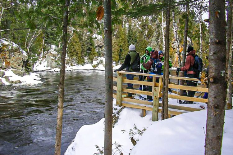
This group of five communities offers visitors the opportunity to walk in a watershed. The route was already used by Aboriginal people. Today, the power stations are joining the walking trails. Each of the trails is marked by a body of water in addition to the many viewpoints from which you can enjoy the scenery.
- electrocardiogram Easy
- mountain 16.8 Km (Mixed)
Sections
L'Attaway
- electrocardiogram Easy
- mountain 3.48 km (Linear)
Access : Two entrances - on the way of the Rapids and on the way of the Power. Provide a vehicle at the exit regardless of your departure from east or west.
Interest : Several ecosystems and habitats, magnificent views of the Ottawa River, presence of water throughout this route, small islands.
L'Île des Rapides
- electrocardiogram Easy
- mountain 3.19 km (Loop)
Access : Two access points, one near the Rapides-des-Îles power plant and the other on the edge of the second entrance parking lot.
Interest : Island became a peninsula in 1964 following the construction of the hydroelectric power plant, path along the banks, various bays, majestic red pines, large erratic blocks, presence of water throughout the loop.
La Grande Île
- electrocardiogram Easy
- mountain 9.18 km (Loop)
Access : At the Bryson Bridge on Rapids Island Road.
Interest : Former spring portage of travellers and first nations. Meandering along Bryson Creek, mountain climb, series of small lakes, Bryson Dyke, lycopods ubiquitous.
La Tour à Feu
- electrocardiogram Easy
- mountain 0.94 km (Linear)
Access : Left on the road of Rapids-des-Iles after the fork with the way of Power.
Interest : Fire tower (observation tower used as a forest fire detection system at the time).
Points of service and interest
Category Name
-
 Parking
Stationnement du sentier La Grande Île
47°35'05.5"N
Parking
Stationnement du sentier La Grande Île
47°35'05.5"N
79°21'19.7"O -
Parking
Stationnement du sentier La tour de feu
47°34'8,159"N
79°18'54,299"O -
Parking
Stationnement du sentier île des Rapides
47°34'20.8"N
79°20'46.7"O -
Parking
Stationnement du sentier L'île des rapides
47°34'29.1"N
79°19'59.3"O -
 Panorama
Point d'intérêt sur le sentier Attaway
47°35'11,717"N
Panorama
Point d'intérêt sur le sentier Attaway
47°35'11,717"N
79°18'17,554"O -
Panorama
Point de vue sur le sentier Attaway
47°34'56,46"N
79°18'41,821"O -
Panorama
Point de vue sur le sentier de l''île des rapides
47°34'35,879"N
79°20'10,021"O -
Panorama
Point de vue sur le sentier La grande île
47°35'35,099"N
79°20'25,08"O -
 Picnic table
Point de vue sur le sentier La grande île
47°35'47,58"N
Picnic table
Point de vue sur le sentier La grande île
47°35'47,58"N
79°20'2,519"O -
 Point of interest
Petites marmites du sentier Attaway
47°34'43,799"N
Point of interest
Petites marmites du sentier Attaway
47°34'43,799"N
79°19'16,201"O -
 Wild camping
Camping sauvage du sentier L'île des rapides
47°34'38,701"N
Wild camping
Camping sauvage du sentier L'île des rapides
47°34'38,701"N
79°20'15,839"O
Accessibility
Access Rights
 Free, no reception infrastructure.
 ![]() Dogs are welcome.
Dogs are welcome.
Directions to the starting point
From Notre-Dame-du-Nord, take Highway 101 north. Drive through the village of Timiskaming First Nation, then after 1.2 km turn right onto Hydro-Québec road. From Rouyn-Noranda, turn left onto Hydro-Québec Road.
Turn left onto the Rapides-des-Îles trail and travel 7.8 km to reach the Bryson bridge where the La grande île trail starts. To reach the access points of the trails L'île des rapides and L'Attaway continue further on the path of the Rapides-des-Îles. To reach the access points of the trails The explorer and The powers of the water, continue further on the path of the rapids-of-islands then turn left on the way of the power.
The trails are also accessible in the opposite direction by way of Giovani to Angliers but this one is no longer maintained.
Contact
P 819 685-2301
Email : contact@recre-eaudesquinze.qc.ca
Trail Marking
Wood and orange ribbon.
Natural Environment
History
In 1920, the Northern Québec Power Company decided to control the waters by building a hydroelectric plant.
Toponymy
ATTAWAY means "sell" in Algonquin.
Comments social0
Tools ready to go
- mapsquare Download GPS track (GPX)
- Google driving directions
-
 Sunrise : 07:29
Sunset : 18:37 -
Equipment for rent Coop de l'Arrière-Pays
Info & advice
- Animation et interprétation
- Camping
- Care
- Carte et orientation
- Clothes
- Emergency
- Equipment
- Nutrition
- Prevention
- Training
Caution
This sheet has been prepared from information provided by outdoor enthusiasts deemed sufficiently reliable and experienced. Errors or omissions are always possible and Tourisme Abitibi-Témiscamingue cannot accept responsibility for any problem or accident that may arise from this sheet or be attributed to its use. If you notice any errors or omissions during your expedition, we would be very grateful if you would let us know by email pleinair@atrat.org in order to keep our information up to date.
