
Upper Outaouais Paddling Trail
Upper Outaouais Paddling Trail
Rouyn-Noranda (McWatters), Rouyn-Noranda
Kinojévis River / Outaouais Rivers / Simard Lake / Grassy Lake / Lac des Quinze Lake
- electrocardiogram Moderate
- mountain 125 Km (Linear)
- calendar seasonal
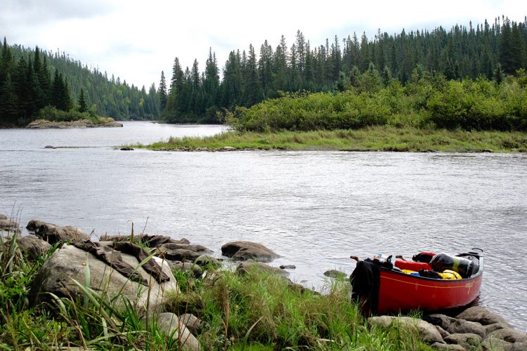
Sections
PortageRapideEsturgeon
- electrocardiogram Easy
- mountain 0.87 km (Linear)
Kinojévis River
- electrocardiogram Easy
- mountain 42,6 km (Linear)
Access : By the waterboarding near the bridge on Highway 117.
Interest : Wilderness, discrete relief, clay and rocky shores, presence of multiple hunting camps on the banks.
Outaouais Rivers
- electrocardiogram Moderate
- mountain 32,6 km (Linear)
Access : By the Kinojevis River.
Interest : Very wild and isolated environment, discreet relief, clay and rocky shores.
Danger : Presence of many surface rocks in the rapids of the Esturgeon and important difference in altitude making the descent impossible.
Simard et Grassy Lakes
- electrocardiogram Moderate
- mountain 10,2 km (Linear)
Access : By the Outaouais River.
Interest : Low relief, large lakes, grassy bridge Narrow, beach.
Danger : Tumultuous by strong wind.
Lac des Quinze Lake
- electrocardiogram Moderate
- mountain 39,6 km (Linear)
Access : By Grassy Lake.
Interest : Multitude of beaches, wild environment, walnut relief, clear water, chalets and residence on the left bank, from Lake des Quinze to the village of Moffet, chalets and residences on the left bank near Angliers.
Danger : Tumultuous by strong wind, circulation of motor boats, large dam at Angliers.
Points of service and interest
Category Name
-
 Sandy beach / Swimming
Plage du camping
47°30'30.721”N
Sandy beach / Swimming
Plage du camping
47°30'30.721”N
79°2'37.401”O -
 Wild camping
Camping sauvage de La Natche
48°10'4.708”N
Wild camping
Camping sauvage de La Natche
48°10'4.708”N
78°53'10.563”O -
Sandy beach / Swimming
Plage des rapides de l’Esturgeon
47°44'56.462”N
78°44'22.552”O -
 Rapids
Rapides de l’Esturgeon
47°45'6.105”N
Rapids
Rapides de l’Esturgeon
47°45'6.105”N
78°44'41.656”O -
 Boat launching site
Rampe de mise à l’eau de la rivière Kinojévis à Rouyn-Noranda
(chemin du Vieux-Pont Est)
48°12'28.074”N
Boat launching site
Rampe de mise à l’eau de la rivière Kinojévis à Rouyn-Noranda
(chemin du Vieux-Pont Est)
48°12'28.074”N
78°51'44.007”O -
Sandy beach / Swimming
Plages du lac des Quinze
-
Wild camping
Camping sauvage du lac Vallet
48°10'58.84”N
78°53'0.623”O -
 Kayak for rent
Aventures Obikoba 1295, chemin de l'ÉgliseRémigny, Québec, J0Z 3H0T. 1 819 761-2128
47°45'42,93"N
Kayak for rent
Aventures Obikoba 1295, chemin de l'ÉgliseRémigny, Québec, J0Z 3H0T. 1 819 761-2128
47°45'42,93"N
79°12'31,34"O -
 Point of interest
Pointe aux Allemands
48°8'2.2”N
Point of interest
Pointe aux Allemands
48°8'2.2”N
78°53'22.745”O -
Sandy beach / Swimming
Plage du Grassy Narrow
47°38'29.77”N
78°50'48.774”O -
Sandy beach / Swimming
Plage à l’embouchure du lac Simard
47°40'32.238”N
78°43'27.106”O -
 Carrying
Portage des rapides de l’Esturgeon
47°45'3.569”N
Carrying
Portage des rapides de l’Esturgeon
47°45'3.569”N
Accès 1 : -
 Launching ramp
Rampe de mise à l’eau du lac Kinojévis à Rouyn-Noranda
(chemin des rangs 9 et 10 Est)
48°7'47.176”N
Launching ramp
Rampe de mise à l’eau du lac Kinojévis à Rouyn-Noranda
(chemin des rangs 9 et 10 Est)
48°7'47.176”N
78°53'44.532”O -
Wild camping
Camping sauvage de la baie des Indiens du lac des Quinze
47°30'34.055”N
79°2'34.332"O -
Sandy beach / Swimming
Petite plage avec galets
47°32'38.404”N
78°59'34.377”O -
Launching ramp
Marina Paul Coulombe
(15, rue du T E Draper, Angliers)
47°33'4.507"N
79°13'59.709"O -
Wild camping
Camping sauvage du Grassy Narrow
47°38'29.77"N
78°50'48.774"O -
Launching ramp
Rampe de mise à l’eau de Moffet
(rue du Quai, Moffet)
47°33'2.921”N
78°57'17.466”O -
Wild camping
Camping sauvage à l'embouchure du lac Simard
47°40'32.238"N
78°43'27.106"O -
Launching ramp
Rampe de mise à l’eau du Grassy Narrow
(chemin de Grassy Narrow, Moffet)
47°37'27.322"N
78°51'48.368"O -
Wild camping
Camping sauvage des rapides de l'Esturgeon
47°44'57.244"N
78°44'23.859"O -
Launching ramp
Rampe de mise à l’eau en aval de la Baie Caron
(chemin des rangs 7 et 8 Est, quartier Bellecombe à Rouyn-Noranda)
48°5'54.57"N
78°51'58.037"O -
Wild camping
Camping sauvage à l'embouchure de la rivière des Outaouais
47°55'21.39"N
78°39'27.299"O -
Sandy beach / Swimming
Plage à l’embouchure du lac des quinze
47°35'38.248"N
78°54'59.354"O
Accessibility
Indication to reach the starting point
From Rouyn-Noranda, take route 117 south. After the bridge, turn right on the chemin des Draveurs. Turn right on the Old Bridge East road to the gravel launch ramp.
Free outdoor parking and launching ramp.
Position : 78°51'44,007"O 48°12'28,074"N
To reach the point of arrival
In Angliers, on route 391, take the rue du T.E. Draper until the launching ramp.
Outdoor parking and launching ramp.
Position : 79°13'59,709"O 47°33'4,507"N
Specifications
Topographic Maps
Topographic maps at a scale of 1/50,000 exist for the entire river course and we recommend that you use them in conjunction with this guide map.
32 D/2 Kinoj River, Vallet Lake, Kinojévis Lake
31 M/15 Kinojévis River, Ottawa River
31 M/10 Ottawa River, Simard Lake, Grassy Lake, Lac des Quinze
31 M/11 Lac des Quinze
Total slope: 1 meter
Danger, fast and carry
Presence of many surface rocks in the rapids of the Esturgeon and important difference in altitude making the descent impossible. Well-maintained portage trail. Simard, Grassy and des Quinze lakes are very tumultuous and even dangerous in high winds. It is recommended to walk along the shoreline.
Campsite
Campsites are insufficient at the beginning of the route between the Grande Île and the mouth of the Ottawa River, and very sufficient and beautiful afterwards.
Natural Environment
Geology
Bassin hydrographique du Saint-Laurent
The upper Ottawa River flows southward, forms Lake Ottawa and ends at Lake Temiscamingue to the north.
Fauna
The course is known for its very diverse wildlife which includes, among others, black duck, kingfisher, great heron, great woodpecker, porcupine, red squirrel, beaver, muskrat, hare, weasel, marten, mink, striped mouffette, otter, orignal, black bear, white deer, grey wolf, coyote, red fox, lynx.
Flora
Water bodies are located in the areas of white birch and yellow birch fir trees, which include, among others, cedar, white and black spruce, balsam fir, white pine, red pine, aspen, yellow birch, maple and hemlock.
History
The history of the Ottawa River and Lake of the Fifteen is at the heart of the Algonquin nation. This river network has always been included in the center of their land. These bodies of water were for a long time the preferred route by the Amerindians and the first explorers to reach the north. They were also borrowed by the colonizers to allow them access to land to be burned and then ploughed. They were then used for the drave from the creation of Témiscamingue at the end of the 19th century.
Typology
The current name of the river comes from a tribe originally from Manitoulin Island (located in Lake Huron) that used it to come and trade fur with the first French explorers. Its Algonquin name, Kitchesippi, means Great River.
Comments social0
Tools ready to go
- map Guide map (PDF)
- mapsquare Download GPS track (GPX)
- Google driving directions
-
 Sunrise : 07:29
Sunset : 18:35 - Water level
-
Equipment for rent Coop de l'Arrière-Pays
- pdf Planification
- pdf Pmu Outaouais
- pdf Ps Outaouais
- pdf Autoevaluation Kayak
- pdf Equipement Kayak
- pdf Trousse Kayak
- pdf Autoevaluation Canot
- pdf Equipement Canot
- pdf Trousse Canot
Info & advice
- Animation et interprétation
- Camping
- Care
- Carte et orientation
- Caution
- Classification
- Emergency
- Equipment
- Jamais sans mon chien
- Nutrition
-
Prevention
- 10 articles de première nécessité
- Bien s'hydrater
- Comment lire la météo dans les nuages? Faire la pluie et le beau temps !
- Connaître son groupe et son plan d’eau
- Éviter les mauvaises rencontres en milieu sauvage
- Feu de camp sécuritaire : trois étapes à respecter
- Insectifuges
- Les moustiques
- Lunettes de soleil
- MALADIE DE LYME : PRÉVENIR LES PIQÛRES DE TIQUE EN RANDONNÉE
- Perdu en forêt : quoi faire?
- Règles de sécurité en canot et en kayak
- Se protéger contre le soleil
- Signalisation nautique internationale
- Vaporisateur Chasse-ours
- Progression
- Réglementation
- Training
Caution
This sheet has been prepared from information provided by outdoor enthusiasts deemed sufficiently reliable and experienced. Errors or omissions are always possible and Tourisme Abitibi-Témiscamingue cannot accept responsibility for any problem or accident that may arise from this sheet or be attributed to its use. If you notice any errors or omissions during your expedition, we would be very grateful if you would let us know by email pleinair@atrat.org in order to keep our information up to date.
