
Pointe Opémican Paddling Trail
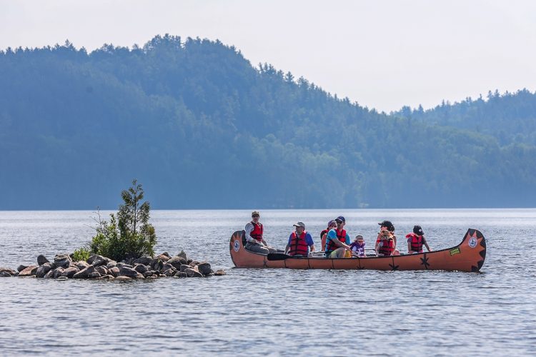
Pointe Opémican Paddling Trail
Témiscaming, Témiscamingue
- electrocardiogram Easy
- mountain 3.4 Km (Linear)
- calendar seasonal
Sections
Parcours pagayable de la Pointe Opémican
- electrocardiogram Easy
- mountain 3.35 km (Linear)
Point Opémican Paddling Course
- electrocardiogram Easy
- mountain 3.35 km (Linear)
Points of service and interest
Category Name
-
 Reception et services
Centre de service de la pointe Opémican et boutique nature
46°50'6,592"N
Reception et services
Centre de service de la pointe Opémican et boutique nature
46°50'6,592"N
79°11'34,221"O -
 Discovery
Moulin à scie
46°50'2,449"N
Discovery
Moulin à scie
46°50'2,449"N
79°12'14,225"O -
 Point of interest
Forge
46°49'56,176"N
Point of interest
Forge
46°49'56,176"N
79°11'29,052"O -
Point of interest
Château d'eau
46°49'54,608"N
79°11'33,217"O -
Point of interest
Garage
46°50'0,361"N
79°11'32,55"O -
Point of interest
Hangar à estacades
46°50'1,488"N
79°11'31,062"O -
 Rocky escarpment
Falaise
46°56'8.908”N
Rocky escarpment
Falaise
46°56'8.908”N
79°18'26.879”O -
Point of interest
Auberge Jodoin
46°49'54,485"N
79°11'30,857"O -
Point of interest
Menuiserie / Chalouperie
46°49'56.1"N
79°11'29.2"O -
Rocky escarpment
Plage de la baie d’Opémican
46°49'58.5”N
79°11'21.759”O -
 Sandy beach / Swimming
Pit de sable
46°50'3.817”N
Sandy beach / Swimming
Pit de sable
46°50'3.817”N
79°11'31.3”O -
 Commercial campsite
Camping 2 services (eau, électricité), secteur des Draveurs (boucle A)
46°50'5,919"N
Commercial campsite
Camping 2 services (eau, électricité), secteur des Draveurs (boucle A)
46°50'5,919"N
79°11'45,241"O -
Commercial campsite
Camping sans service sur l'emplacement, secteur des Cageux (boucle B)
46°50'12,786"N
79°11'49,498"O -
 Ready-to-camp for rent
Prêt-à-camper Étoile, secteur des Remorqueurs (boucle C)
46°50'0,924"N
Ready-to-camp for rent
Prêt-à-camper Étoile, secteur des Remorqueurs (boucle C)
46°50'0,924"N
79°11'48,665"O -
 Toilet
Bloc sanitaire
46°50'6,53"N
Toilet
Bloc sanitaire
46°50'6,53"N
79°11'51,34"O
Comments social0
Tools ready to go
- mapsquare Download GPS track (GPX)
- Google driving directions
-
 Sunrise : 07:28
Sunset : 18:37 -
Equipment for rent Parc national d'Opémican Coop de l'Arrière-Pays
Info & advice
- Animation et interprétation
- Camping
- Care
- Carte et orientation
- Caution
- Classification
- Emergency
- Equipment
- Jamais sans mon chien
- Nutrition
-
Prevention
- 10 articles de première nécessité
- Bien s'hydrater
- Comment lire la météo dans les nuages? Faire la pluie et le beau temps !
- Connaître son groupe et son plan d’eau
- Éviter les mauvaises rencontres en milieu sauvage
- Feu de camp sécuritaire : trois étapes à respecter
- Insectifuges
- Les moustiques
- Lunettes de soleil
- MALADIE DE LYME : PRÉVENIR LES PIQÛRES DE TIQUE EN RANDONNÉE
- Perdu en forêt : quoi faire?
- Règles de sécurité en canot et en kayak
- Se protéger contre le soleil
- Signalisation nautique internationale
- Vaporisateur Chasse-ours
- Progression
- Réglementation
- Training
Caution
This sheet has been prepared from information provided by outdoor enthusiasts deemed sufficiently reliable and experienced. Errors or omissions are always possible and Tourisme Abitibi-Témiscamingue cannot accept responsibility for any problem or accident that may arise from this sheet or be attributed to its use. If you notice any errors or omissions during your expedition, we would be very grateful if you would let us know by email pleinair@atrat.org in order to keep our information up to date.
