
Opemican Archipelago Paddling Trail
Opemican Archipelago Paddling Trail
Laniel, Témiscamingue
- electrocardiogram Easy to Moderate
- mountain 27.1 Km (Mixed)
- calendar seasonal
Sections
Accès Laniel
- electrocardiogram Easy
- mountain 6.74 km (Linear)
Accès Baie Dorval
- electrocardiogram Easy
- mountain 2.50 km (Linear)
Boucle de la presqu'île de la Baie Dorval
- electrocardiogram Easy
- mountain 4.62 km (Linear)
Portage
- electrocardiogram Easy
- mountain 0.03 km (Linear)
Boucle des îles du Sandy Portage
- electrocardiogram Easy
- mountain 3.88 km (Linear)
Bouble de l'île aux Fraises
- electrocardiogram Easy
- mountain 10.37 km (Linear)
Points of service and interest
Category Name
-
 Reception et services
Poste d'accueil de Laniel et boutique nature
47°02'31.8"N
Reception et services
Poste d'accueil de Laniel et boutique nature
47°02'31.8"N
79°16'12.1"O -
 Launching ramp
Rampe de mise à l'eau de la marina de Laniel
47°2'31,038"N
Launching ramp
Rampe de mise à l'eau de la marina de Laniel
47°2'31,038"N
79°16'10,051"O -
 Paid wild camping
Camping rustique des îles du Sandy Portage (Parc national d'Opémican)
46°58'59,815"N
Paid wild camping
Camping rustique des îles du Sandy Portage (Parc national d'Opémican)
46°58'59,815"N
79°12'18,61"O -
Paid wild camping
Camping sauvage de l'île du Sandy Portage
46°59'24,853"N
79°12'6,378"O -
Paid wild camping
Plage de l'île aux Fraises
46°58'37,779"N
79°11'26,865"O -
 Sandy beach / Swimming
Plage de la pointe de sable
46°59'58.504"N
Sandy beach / Swimming
Plage de la pointe de sable
46°59'58.504"N
79°11'54.4"O -
 Wild camping
Camping sauvage de la pointe de sable
46°59'57,294"N
Wild camping
Camping sauvage de la pointe de sable
46°59'57,294"N
79°11'54,944"O -
 Rocky escarpment
Escarpement rocheux du secteur des îles du Sandy Portage
46°58'54.6"N
Rocky escarpment
Escarpement rocheux du secteur des îles du Sandy Portage
46°58'54.6"N
79°11'55.4"O -
 Carrying
Portage de la baie des Dorval
46°59'15.8"N
Carrying
Portage de la baie des Dorval
46°59'15.8"N
79°13'11.9"O -
Carrying
Portage de la baie Dorval
46°59'15.5"N
79°13'10.1"O -
 Dock
Quai du parc national d'Opémican de la baie Dorval
46°58'43,223"N
Dock
Quai du parc national d'Opémican de la baie Dorval
46°58'43,223"N
79°15'2,279"O -
Wild camping
Camping sauvage de l'île près de la baie Dorval
47°00'36,3"N
79°13'25,2"O -
Wild camping
Camping de la baie McAdam
47°01'19,9"N
79°14'15,2"O -
 Canoe for rent
Parc national d'Opémican, poste d'accueil Laniel
46°58'43.2"N
Canoe for rent
Parc national d'Opémican, poste d'accueil Laniel
46°58'43.2"N
79°15'02.3"O -
 Parking
Stationnement du quai municipal de Laniel
47°02'35.5"N
Parking
Stationnement du quai municipal de Laniel
47°02'35.5"N
79°16'09.1"O
Accessibility
 Directions to the arrival point
DORVAL BAY
From Ville-Marie, take Route 101 South. Pass the town of Laniel and turn left onto Chemin Baie-Dorval. At Y, turn left.
From Témiscaming, take Route 101 North. Before the town of Laniel, turn right onto Chemin Baie-Dorval. At Y, turn left.
![]() View the route from your location on Google Maps
View the route from your location on Google Maps
LANIEL
From Ville-Marie, take Route 101 South. In the town of Laniel, turn left into the Laniel Municipal Park until you reach the launching ramp.
From Témiscaming, take Route 101 North. In the town of Laniel, turn right to enter Laniel Municipal Park until you reach the launching ramp.
Public and free outdoor parking Position: 79°16'09,0"W 47°02'35,1"
Specifications
 Water level
Data sheet of the "Kipawa Dam" station.
 Obstacles et dangers
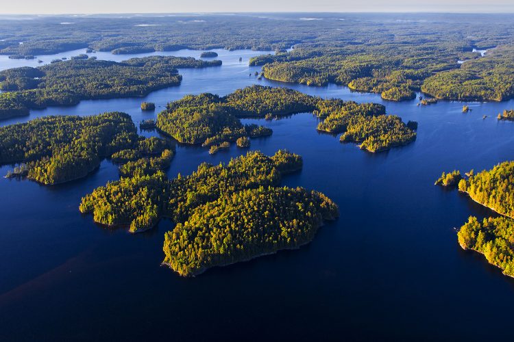
- The Kipawa reservoir is composed of a hundred bays and has a multitude of islands. It is very easy to feel disoriented and get lost while navigating this immense expanse of water. It is therefore absolutely necessary to have in your possession a GPS in which you have previously downloaded the route and enough batteries for the duration of your stay. It is also important to have a paper water map and compass.
- Lake Kipawa is tumultuous and even dangerous when there are strong winds. It is recommended to go along the shores. Some sections run along large rock walls without any possibility of landing.
- The wind can change rapidly in strength and direction. It can create short, sharp waves that make it difficult to maintain a direction that could destabilize boats and cause them to capsize.
- Near the large rock walls, the waves collide with each other (swells) making boats unstable.
 Campsite
Campsites are sufficient and of quality located on peaks, beaches and islands.
They are distributed along the course. It is essential to leave the campsites in an impeccable condition following the principles of ethics Sans Trace.
 Human presence
Several residences on the shores of Dorval Bay. Presence of motor boats.
Natural Environment
History
Kipawa Lake Area
As early as the mid-18th century, several forestry companies began harvesting the white and red pine forests of the Kipawa. At the end of the 19th century, J. R. Both Lumber was well established.
Part of the Kipawa River became a reservoir following the construction of the Laniel and Kipawa dams in 1911. The Kipawa Dam, built to supply electricity to the plant and the city of Témiscamingue, is located at the mouth of Gordon Creek near the municipality of Kipawa.
Geography
With an area of 300 km2 and 1,307 km of banks characterized by many rocky cliffs, this body of water extends over five cantons. The lake is complex in form, being connected with several other bodies of water: Green, Grindstone, Bedout, McLachlin, Sheffield, Audoin, Sheffield, Trout, Hunter, Sunnyside and Moran.
The water reaches a maximum depth of 40 meters and its average depth is 11.5 meters.
The main hydrographic slopes of the Kipawa reservoir are:
- North side: l'Africain stream, Lavallée river;
- East side: Lake Bois Franc which flows into the Kipawa River;
- Southwest: Beauchêne river draining Beauchêne lake, Petit lac Beauchêne, Windy, du Diable, Pin Blanc, Grand lac George and Petit lac Georges;
- East side: the Ottawa River.
The reservoir is a veritable maze consisting of:
- Berries: Chemagan, des Plongeurs, Profonde, du Huard, Dorval, Pratt, des Anglais, Campbell, McLaren, Dubreuil, Coalpit Bay, Trout and Pratt;
- Islands: McKenzie, Fox, Bears, Big Moose Island, Garrot, Strawberry, Turtle, Bronson and Latour.
- Peninsulas.
The Kipawa tank is powered by:
- North side: Carr Lake discharge; Moran Lake, St-Amand, Grand Knife Lake and Guay Lake; Coeur Lake discharge; Caribou Lake discharge; Aubry Lake discharge; Bat Lake discharge; Clément, Jack-White and McKeown Lake discharge; Raisenne Lake discharge; Audoin Lake; Hunter Point Lake; Little Grindstone Lake; McCullough Lake; McKillop Lake;
- East side: McLachlin Lake; McKillop Lake discharge; Kipawa River;
- South side: discharge from Trout Lake (which empties into Pratt Bay).
Wildlife
The species observed on the Kipawa reservoir are the loon, the great heron, the osprey, the American crane, the bald eagle and a multitude of ducks.
Flora
Red pine giants, often tricentenaires or more, line the Kipawa reservoir in several places. There are also sugar maple trees and black ash trees. This body of water is characterized by areas with a high concentration of mature forests, including McKenzie Island, which has never been extensively logged.
Toponymy
The name Kipawa comes from Algonquin and means "It’s closed". The toponym was spelled in many ways before the Kipawa variant became official: Kippawa, Kippewa, Kepawa, Kipakowe, Kipahowe.
Comments social0
Tools ready to go
- mapsquare Download GPS track (GPX)
- Google driving directions
-
 Sunrise : 07:29
Sunset : 18:38 -
Equipment for rent Parc national d'Opémican, secteur Laniel Coop de l'Arrière-Pays
- pdf Planification
- pdf Equipement Canot
- pdf Trousse Canot
- pdf Equipement Kayak
- pdf Trousse Kayak
- pdf Autoevaluation Canot
- pdf Autoevaluation Kayak
- pdf Pmu
- pdf Ps
- pdf Systemes Communications
Info & advice
- Animation et interprétation
- Camping
- Care
- Carte et orientation
- Caution
- Classification
- Emergency
- Equipment
- Jamais sans mon chien
- Nutrition
-
Prevention
- 10 articles de première nécessité
- Bien s'hydrater
- Comment lire la météo dans les nuages? Faire la pluie et le beau temps !
- Connaître son groupe et son plan d’eau
- Éviter les mauvaises rencontres en milieu sauvage
- Feu de camp sécuritaire : trois étapes à respecter
- Insectifuges
- Les moustiques
- Lunettes de soleil
- MALADIE DE LYME : PRÉVENIR LES PIQÛRES DE TIQUE EN RANDONNÉE
- Perdu en forêt : quoi faire?
- Règles de sécurité en canot et en kayak
- Se protéger contre le soleil
- Signalisation nautique internationale
- Vaporisateur Chasse-ours
- Progression
- Réglementation
- Training
Caution
This sheet has been prepared from information provided by outdoor enthusiasts deemed sufficiently reliable and experienced. Errors or omissions are always possible and Tourisme Abitibi-Témiscamingue cannot accept responsibility for any problem or accident that may arise from this sheet or be attributed to its use. If you notice any errors or omissions during your expedition, we would be very grateful if you would let us know by email pleinair@atrat.org in order to keep our information up to date.
