
Hiking Trails and Grand Heron Observation Post - TEMPORARILY CLOSED
Hiking Trails and Grand Heron Observation Post - TEMPORARILY CLOSED
Macamic, La Sarre et l'Abitibi-Ouest
TEMPORARILY CLOSED - The trails on the wooden sidewalk were damaged by the fire
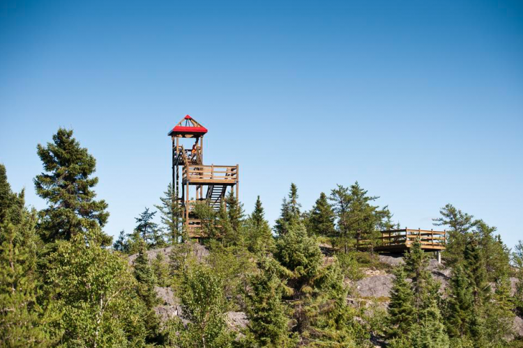
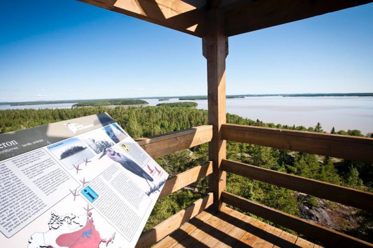
This trail network is part of the Macamic Hikers' Route, a route made up of four independent locations. The hike begins with an old forest path through a mixed forest. Climbing the hill, trees are gradually replaced by rocky outcrops covered with shrubs and mosses. A 10 m high observation tower and lookout at the top of the hill provides views of the islands of Lake Macamic, one of which is home to a heron tree, and the surrounding area. The course is decorated with 13 interpretive panels dealing with fauna and flora.
- electrocardiogram Easy
- mountain 2 Km (Mixed)
- calendar seasonal
Sections
Le Grand Héron - Entrée
- electrocardiogram Easy
- mountain 0.19 km (Linear)
Le Grand Héron - Boucle
- electrocardiogram Easy
- mountain 0.95 km (Loop)
Le Grand Héron - Lac
- electrocardiogram Easy
- mountain 0.35 km (Linear)
Points of service and interest
Category Name
-
 Parking
Stationnement du Poste d'observation du Grand Héron
48°49'18,576"N
Parking
Stationnement du Poste d'observation du Grand Héron
48°49'18,576"N
78°59'56,24"O -
 Observation tower
Tour d'observation du Grand Héron
48°49'10,286"N
Observation tower
Tour d'observation du Grand Héron
48°49'10,286"N
78°59'37,349"O -
 Picnic table
Table de pique-nique
48°49'10.2"N
Picnic table
Table de pique-nique
48°49'10.2"N
78°59'37.4"O -
Picnic table
Table de pique-nique
48°49'01.5"N
78°59'38.0"O -
 Panorama
Point de vue boucle du Grand Héron
48° 49.230'N
Panorama
Point de vue boucle du Grand Héron
48° 49.230'N
78° 59.738'O -
 Toilet
te du sentier du Grand Héron
48° 49.307N
Toilet
Toilette du sentier du Grand Héron
48° 49.307N
78° 59.925'O
Accessibility
Access Rights
 Free, without visitor facilities.
 ![]() Pets are allowed.
Pets are allowed.
Directions to the starting point
From La Sarre: Head south on Route 393. Turn left onto Route 111 South (10.9 km). Turn left onto Macamic-Chazel Road (3.2 km). Turn right onto 6th and 7th Range East (4.3 km). Turn right onto Chemin du Lac de Courval (1.5 km). Your destination is straight ahead.
From Amos: Take Route 111 North to Macamic (76 km). After 5 km past Macamic, turn right onto Macamic-Chazel Road (3.2 km). Turn right onto 6th and 7th Range East (4.3 km). Turn right onto Chemin du Lac de Courval (1.5 km). Your destination is straight ahead.
From Rouyn-Noranda: Take Route 101 North to Macamic (64 km). In Macamic, turn left onto Route 111 North (5 km). Turn right onto Macamic-Chazel Road (3.2 km). Turn right onto 6th and 7th Range East (4.3 km). Turn right onto Chemin du Lac de Courval (1.5 km). Your destination is straight ahead.
Parking: Free
Coordinates: 48°49'21.0"N 78°59'43.4"O
![]() View the route from your location on Google Map
View the route from your location on Google Map
Contact
T 819 782-4604 ext.225
Specifications
- Elevation: maximum 50 km
Comments social0
Tools ready to go
- pdf Planification Randonnee Apa
- pdf Equipement Randonnee Pedestre
- pdf Gestion Des Risques Randonnee Pedestre Apa
- pdf Sans Trace Apa
Info & advice
- Activité
- Animation et interprétation
- Camping
- Care
- Carte et orientation
- Caution
- Emergency
- Encadrement
- Equipment
- Jamais sans mon chien
- Nutrition
-
Prevention
- 10 articles de première nécessité
- Bien s'hydrater
- Comment lire la météo dans les nuages? Faire la pluie et le beau temps !
- Éviter les ampoules aux pieds
- Éviter les mauvaises rencontres en milieu sauvage
- Feu de camp sécuritaire : trois étapes à respecter
- Insectifuges
- Les moustiques
- Lunettes de soleil
- MALADIE DE LYME : PRÉVENIR LES PIQÛRES DE TIQUE EN RANDONNÉE
- Perdu en forêt : quoi faire?
- Se protéger contre le soleil
- Vaporisateur Chasse-ours
- Progression
- Réglementation
- Training
Caution
This sheet has been prepared from information provided by outdoor enthusiasts deemed sufficiently reliable and experienced. Errors or omissions are always possible and Tourisme Abitibi-Témiscamingue cannot accept responsibility for any problem or accident that may arise from this sheet or be attributed to its use. If you notice any errors or omissions during your expedition, we would be very grateful if you would let us know by email pleinair@atrat.org in order to keep our information up to date.
